Blog
Revolutionizing Regenerative Agriculture with Remote Sensing and AI
September 25, 2023
Get the latest from CIBO. Stay connected with news, expert insights and exclusive event invitations.
SubscribeOne of the most exciting advancements in regenerative agriculture programs is the marriage of remote sensing and artificial intelligence (AI). Together, these technologies are transforming our ability to monitor the management of row crops. Modern programs focused on regenerative farming, Scope 3 emissions reduction, and carbon sequestration require reliable insights about on-the-ground management practices. Historically, this information was collected through time-consuming surveys or disrupting interviews with farmers. While valuable, the time needed to undertake these efforts made it impossible to scale them up and cover the entire country. Now, with satellite-based remote sensing and AI, these insights are delivered instantly, at scale, at high resolution, and, importantly, without disrupting farmers. In this blog post, we will explore what remote sensing is and how these cutting-edge technologies are reshaping the agricultural landscape.
Understanding Remote Sensing and AI at CIBO:
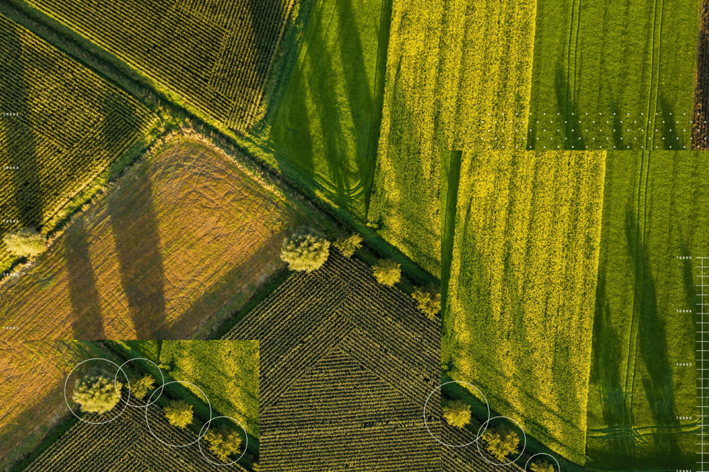
Remote sensing involves acquiring information about an object or phenomenon from a distance, typically using specialized sensors and instruments. Computer vision is a method for analyzing and extracting meaningful information from images. Images might be captured by satellites or drones. At CIBO Technologies, we use satellite-based remote sensing. Image data from satellites is processed through proprietary pipelines and analyzed with state-of-the-art AI models. We deliver analyses of agricultural ecosystem scenarios and conclude what—down to the specific variable— outcomes have occurred. CIBO’s computer vision algorithms can accomplish this incredible feat even when there is limited or low-quality data.
The attributes and insights we detect are used directly and as inputs into our mechanistic crop modeling system creating additional insights about carbon intensity, carbon sequestration, biomass, yield, soil erosion, water retention, and numerous other factors.
CIBO’s computer vision algorithms deliver all of these insights:
- CIBO Crop ID: a 10-meter resolution map of land use classes, a similar but substantially improved and higher resolution version of USDA’s CDL
- Field management practice history, including:
- Tillage Detection
- Cover crop detection
- Field boundary detection
- Road detection
- Planting date
- Harvest date
- Crop phenology
Estimating land cover from images is called land cover classification, and it is a very important task in remote sensing. The most well-known instance of this is the Cropland Data Layer (CDL), a product released annually by the USDA National Agricultural Statistics Service (NASS). CDL is produced using a decision tree algorithm to classify pixels into one of 133 classes, including crop (e.g., corn and soybean) and non-crop (e.g., forest and water) cover types. Its purpose is to provide “acreage estimates to the Agricultural Statistics Board for major commodities and to produce digital, crop-specific, categorized geo-referenced output products.” Since 2008, the US CDL has covered the entire continental US. Now, in 2023, we are releasing CIBO Crop ID.CIBO Crop ID is CIBO’s productized data offering that improves on the USDA CDL in three important ways:
- Early availability: CIBO has streamlined the process for training and applying reliable computer vision models to the extent that CIBO’s Crop ID is released months earlier than the USDA’s CDL. CIBO’s Crop ID data set for the 2023 crop year is available in October 2023 whereas the USDA CDL will not be available until Q1 2024. Early availability creates a substantial competitive advantage for the companies, program developers, CPGs, retailers, and other CIBO Crop ID consumers with farmland in their supply chains.
- Better resolution: Through our innovation, CIBO’s Crop ID delivers better resolution than USDA CDL. In CIBO Crop ID, the image pixels are 10x10m while in USDA CDL pixels are 30x30m. Better resolution provides a much cleaner and more detailed image set from which practice detection, crop phenology and other insights are derived.
- Better accuracy: Both CIBO Crop ID and USDA CDL identify and label 128 different crops across the continental US. The agreement between CIBO’s Crop ID and USDA’s CDL is extremely high while retaining superior resolution and substantial improvements in identification for some crops (e.g. cotton) . Comparisons between CIBO’s Crop ID, USDA’s CDL, and independent ground truth data that neither model has seen before show conclusively that CIBO’s Crop ID outperforms USDA’s CDL.
This technology allows us to monitor and analyze vast agricultural landscapes efficiently and at a scale previously unimaginable.
“The coupling of the robust SALUS process-based model with advanced satellite imagery and big data analysis makes CIBO Technologies a leader in agricultural assessments, creating a new, scientifically valid, agriculturally based carbon credit marketplace that supports regenerative agriculture and creates new opportunity for individuals and organizations to reduce their carbon footprint.”
- Sotirios Archontoulis, Associate Professor of Integrated Cropping Systems at Iowa State University
Convolutional Neural Networks (CNNs) in Agriculture:
CNNs are a class of deep learning models specifically designed for image processing tasks. Their ability to automatically learn and identify features within images has made them a game-changer in computer vision, including agriculture. Here at CIBO, we use a unique approach. Our remote sensing data set was built on a proprietary CNN model based on the U-Net architecture. This is a fully convolutional neural network model that creates rapid, high confidence image segmentation which is also state of the art.
Here’s how CIBO’s use of CNNs are helping:
- Crop and Cover Crop Detection: CNNs can be trained to identify and delineate different crop types within an image. At CIBO, this enables us to rapidly pre-qualify acres for programs based on crops, cover crops, and practices. It enables crop consultants, agronomists, grower Coops, field management firms and others to identify regions and farms that may benefit from new insights and program opportunities. It helps CPG companies identify specific supply sheds for different products to which they can then make Scope 3 and other regenerative ag programs available.
- Tillage detection: How a farmer tills – or no-tills – their land has a big impact on emissions, carbon, soil health, and other essential factors. CIBO’s CNNs are trained to recognize and distinguish different tillage types from conservation and strip tillage to conventional tillage to no-till.
- Field Boundary Detection and identification of management zones: Identifying fields’ precise areas is vital to accurately quantifying everything from yield to biomass to carbon to emissions. Each year and even each season field boundaries change as crops are rotated, buffer zones are planted, and lower-producing areas of fields are taken out of production for some crops. CIBO CNNs analyze images to identify field boundaries, tillable acres, even identifying roads that cut across and through farm fields. It all means that greater precision can be delivered without the need for direct farmer input.
Transfer Learning for Improved Efficiency:
Transfer learning is a technique where a pre-trained neural network, typically trained on a large dataset for a different task, is fine-tuned for a specific task with a much smaller dataset. In agriculture, transfer learning is invaluable because it reduces the labeled data needed to train effective models. Satellite imagery from diverse sources and regions can be used to pre-train CNNs, making them adaptable to various agricultural environments.
Applications in Regenerative Farming, Scope 3, and Carbon Programs:
Regenerative Farming: Remote sensing, CNNs, and transfer learning enable companies to design programs that work for farmers instead of against them. By leveraging deeper insights about the land and delivering higher confidence, higher resolution insights to program designers and sponsors, growers can implement regenerative agriculture practices such as cover cropping, reduced tillage, and crop rotation with greater precision, higher confidence in ROI and soil health outcomes with zero worry. In addition to paying financial incentives, well-designed programs improve soil health, reduce erosion, and sequester carbon.
Scope 3 Emissions Reduction: Accurate monitoring of crop growth and on-farm practice allows for optimized resource management, reducing agriculture’s environmental footprint, a significant contributor to Scope 3 emissions. Scope 3 programs across the CPG, food-system, and agricultural value chain are increasing in importance and popularity. The ability to craft Scope 3 programs that accurately quantify baseline emissions and carbon intensity and then track reductions season over season and year over year are important if organizations are going to hit their net-zero and Scope 3 emissions reduction targets. The ability to identify ag practices at scale, with high resolution and confidence is the critical component of trustworthy Scope 3 programs. Only CIBO Technologies brings together these capabilities.
Carbon Programs: Satellite-based computer vision models like those created by CIBO help quantify carbon sequestration in agricultural land, supporting verified carbon credit programs that reward farmers for sustainable practices. With high-confidence, high-resolution field boundary, farming practice, and crop identification available at continental scales and combining it with independently verified, mechanistic crop modeling – like CIBO does with SALUS – we are able to create high quality carbon programs that surpass registry requirements and deliver high-value carbon credits to growers and the program sponsoring organizations.
Conclusion:
The fusion of remote sensing, CNNs, and transfer learning is revolutionizing agriculture in the United States and beyond. These technologies empower companies to create realistic and beneficial programs for farmers while creating more economic opportunity and optionality for farmers. Easing the entire qualification process, land identification, supply shed carbon intensity scoring, and farmer enrollment in regenerative programs enhances sustainability efforts and contributes to carbon reduction initiatives. As they evolve, we can expect even more profound transformations in how we grow our food and manage our land resources.